-
Our Community
-
- Welcome Visitors About Durham's Community Climate Remembrance Project Diversity Welcome Statement Life in Durham Places to Stay Places to Eat Places to Park Transportation Schools Oyster River School District Welcome New Homeowners
- Durham Public Library Programs & Events Trails and Town Lands Conservation Commission Land Stewardship Conservation Lands & Parks Conservation Easements Trails Youth Organizations University of New Hampshire Durham Preservation Durham Historic Association
- Volunteer Town of Durham Land Stewardship Public Library UNH Cooperative Extension Churchill Rink Parks & Recreation Recreation Program Calendar Outdoor Recreation Activities Outdoor Recreation Sites Sustainable Durham Recycling Information Swap Shop Information Earth Day 2023
-
- Doing Business
-
Inside Town Hall
-
- Departments Assessing Building Business Office Code Enforcement Information Technology Planning Town Clerk/Tax Collector Parks & Recreation Boards, Commissions & Committees Agricultural Commission Conservation Commission Historic District/Heritage Comm. Other Boards & Committees Planning Board Zoning Board
- DCAT Media Productions DCAT Media - Programming DCAT Media Livestream Zoom Video Meeting Schedule Town Council Town Administration Public Hearings Public Safety Police Fire McGregor Memorial EMS (Ambulance)
- Public Works Engineering Division Operations Division Sanitation Division Water Division Wastewater Division Stormwater Town Directory Telephone Directory by Department Services Directory
-
-
Helpful Resources
-
- Quick Links Assessors Online Database Bids and RFP’s DCAT Media Productions GIS Digital Maps Jobs Online Services Parking Information Social Services Town Holidays Trash Pick Up Holiday Schedule Transfer Station & Recycling Center Information Curbside Refuse Collection by Street Zoom Video Meeting Schedule
- Town Documents Budget & CIP Forms & Applications Master Plan Tax Increment Finance (TIF) Districts Tax Maps Town Charter Town Code Town Reports Town Wide Master Fee Schedule Zoning Ordinance Voter Information
- Contact Us Cemetery Information Social Media Facebook Twitter Town Newsletter Friday Updates Town Meetings & Events Agenda and Minutes Calendar Public Hearing Notices State & U.S. Representatives
-
Weeks Lot
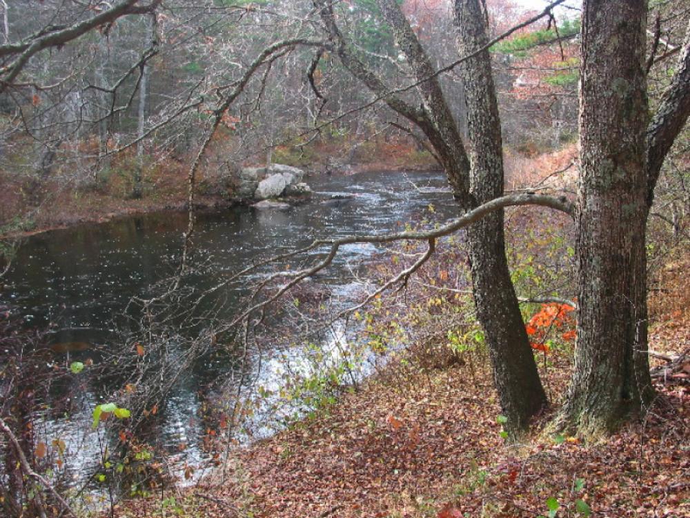
Wiswall Road | 18 acres
DIRECTIONS: From the Durham Town Hall follow Route 108 south approximately 1.6 miles. Turn left onto Bennett Road and follow to the end. Take a right onto Packers Falls Road 0.3 miles to a stop sign. Take a left onto Wiswall Road. The parking area for the Wiswall Dam/John Hatch Park is 0.4 miles on the left. Park here to access the Weeks Lot.
Weeks Lot Map and Property Summary
ABOUT THE PROPERTY:
The Weeks Lot has 50 feet of road frontage, located approximately 1,200 feet east of the Wiswall Bridge over the Lamprey River and approximately 750 feet west of the intersection of Wiswall and Packers Falls Roads. A utility line runs through the northern section of the property. A walking trail runs along the Lamprey River starting at the Wiswall Dam. Although not posted, a section on this trail extends across private property. Except for the small field area near the road frontage, the property is entirely forested. A small white pine plantation is located between the utility line and the northern boundary. Pockets of wetlands are found in the northeast, southeast, and northwest corners of the property. An intermittent stream flows from the wetland in the northwest corner southerly to the Lamprey River.
Before conveying the property to the Town of Durham, the Forest Society placed the following “Conservation Land Use Restrictions” on the property in perpetuity. The following is excerpted from the property deed:
Purposes of Restrictions:
- To maintain the property as open space for conservation
- To protect soil productivity for forests, agriculture, and wildlife
- To protect scenic quality
- To protect surface and ground water
- To preserve and protect the designated “River Front Corridor” as an undisturbed habitat and travel way for wildlife and the water quality of the Lamprey River.